THE SKY IS
YOUR
CANVAS
Aerial photos and video for real estate, construction, brands, events, and action sports. Delivered in 24 to 48 hours.
AERIAL SERVICES
From listing photos that sell homes faster to construction progress documentation and marketing content that drives real business results.
REAL ESTATE
Aerial photography and video that shows your listing's full potential. Lot size, neighborhood context, coastal views. Listings with drone photos sell up to 68% faster, and full-property tours combine aerial footage with ground-level walkthroughs for luxury listings and vacation rentals.
COMMERCIAL VIDEO & MARKETING
Cinematic brand content for wineries, hotels, developers, and Central Coast tourism. Websites, social media, ad campaigns, brand films. Big Sur cliffs, vineyard aerials, coastal sunsets when the work calls for landscape.
CONSTRUCTION PROGRESS
Regular aerial documentation from groundbreaking to ribbon cutting. Time-lapse and milestone reports for developers and investors.
MAPPING & SURVEY
Precision orthomosaic maps and 3D models for construction, agriculture, and large estates. NDAA-compliant for government work.
WEDDINGS & EVENTS
Sweeping venue reveals and ceremony overheads on the Central Coast. Captures the scale, setting, and emotion of your day.
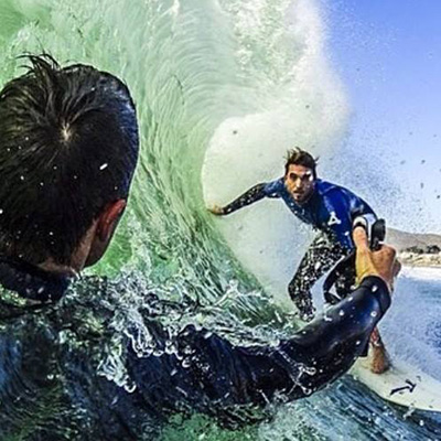
ACTION SPORTS
High-adrenaline 4K 60fps coverage for surfing, MTB, hiking, and outdoor events. Dynamic tracking shots no ground camera can match.
SLO COUNTY
& BEYOND
Based in San Luis Obispo, we serve the entire Central Coast, from Cambria to Santa Maria, Templeton to Shandon.
Every flight is 100% legal, licensed, and insured. We hold active FAA Part 107 Remote Pilot certification, carry dedicated drone liability insurance, and file all required airspace authorizations, including LAANCIE clearances for controlled airspace near SBP and other local airports.
PORTFOLIO
Aerial photography and videography from across San Luis Obispo County and the Central Coast.


SEE US FLY
Real footage from real missions across San Luis Obispo County and the Central Coast.
WHAT CLIENTS SAY
805 Drone takes my listing advertising to the next level. The quality is excellent, and it only takes a few minutes. Marco is friendly and professional and knows exactly what he's doing. I will continue to use 805 Drone and would recommend to anyone in real estate.

Shooting high quality surfing footage with Marco has been amazing. He's quick, precise and professional, and very good at what he does. I highly recommend his work after having worked with other videographers, there's a clear difference in skill.
Marco and his team of professionals do exceptional work. They were on time, fair on price and produced an exceptional product. I just wish there were more stars to click on because five is not enough!
MARCO BRUSCHI
OWNER & PILOT
Based in San Luis Obispo on California's stunning Central Coast, 805Drone was built on a simple idea: give every client, from a first-time home seller to a solar energy company, access to truly professional aerial imagery at a fair price.
Marco has been flying commercially since 2017, logging hundreds of missions across San Luis Obispo County. Whether it's chasing a wave at Sandspit or mapping a 50-acre solar array in Atascadero, he brings the same precision and care to every flight.
SIMPLE PACKAGES
No surprise fees. Every package includes FAA-certified flight, professionally edited deliverables, and a satisfaction guarantee.
- Up to 20 edited aerial photos
- 4K RAW + web-ready JPEGs
- 1-hour on-site session
- 24-hour delivery
- San Luis Obispo County
- 30+ edited aerial photos
- 60-second cinematic video edit
- Twilight / golden hour option
- Music, titles & color grade
- 24-hr photo / 48-hr video delivery
- Countywide coverage included
- Construction progress packages
- Government / NDAA-compliant flights
- FPV & immersive fly-throughs
- 2D/3D mapping & orthomosaics
- Multi-day & recurring shoots
- Flexible scheduling & deliverables
All sessions include FAA-certified pilot, full liability insurance, and satisfaction guarantee. Travel surcharge may apply beyond 30mi from San Luis Obispo.
LET'S FLY
Tell us about your project and we'll get back to you within a few hours with a custom quote. No obligation, no pressure.
Marco will review your message and reply within 2 hours on weekdays. In the meantime, watch the reel below or call (805) 669-7444.
Watch the reel →